
At Ouaneche topographic map
Interactive map
Click on the map to display elevation.
About this map
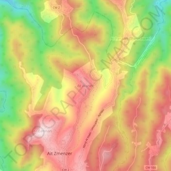
Name: At Ouaneche topographic map, elevation, terrain.
Average elevation: 1,588 ft
Minimum elevation: 577 ft
Maximum elevation: 2,339 ft
Other topographic maps
Click on a map to view its topography, its elevation and its terrain.
Ighil Elmal
Algérie > Tizi Ouzou > Daïra Beni Douala > Beni Zmenzer
Ighil Elmal, Beni Zmenzer, Daïra Beni Douala, Tizi Ouzou, 15029, Algérie
Average elevation: 1,680 ft