
Tignes Les Brevières topographic map
Interactive map
Click on the map to display elevation.
About this map
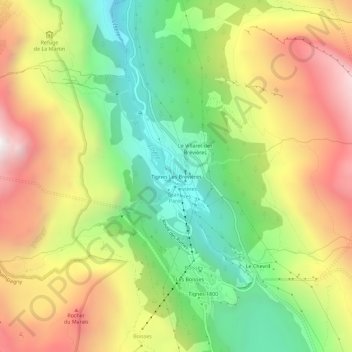
Name: Tignes Les Brevières topographic map, elevation, terrain.
Average elevation: 6,821 ft
Minimum elevation: 4,751 ft
Maximum elevation: 9,275 ft
Other topographic maps
Click on a map to view its topography, its elevation and its terrain.
Val-Claret
France > Auvergne-Rhône-Alpes > Savoy > Tignes
Val-Claret, Tignes, Albertville, Savoy, Auvergne-Rhône-Alpes, Metropolitan France, 73320, France
Average elevation: 7,904 ft