
Grayling Charter Township topographic map
Interactive map
Click on the map to display elevation.
About this map
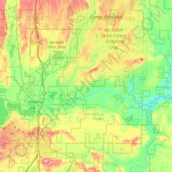
Name: Grayling Charter Township topographic map, elevation, terrain.
Average elevation: 1,207 ft
Minimum elevation: 1,027 ft
Maximum elevation: 1,486 ft
Other topographic maps
Click on a map to view its topography, its elevation and its terrain.
Frederic
United States > Michigan > Crawford County
Frederic, Frederic Township, Crawford County, Michigan, 49733, United States
Average elevation: 1,266 ft
Babbits Resort
United States > Michigan > Crawford County
Babbits Resort, Grayling Charter Township, Crawford County, Michigan, 49738, United States
Average elevation: 1,135 ft
Lovells
United States > Michigan > Crawford County
Lovells, Lovells Township, Crawford County, Michigan, United States
Average elevation: 1,191 ft
Maple Forest Township
United States > Michigan > Crawford County
Maple Forest Township, Crawford County, Michigan, United States
Average elevation: 1,312 ft
Beaver Creek Township
United States > Michigan > Crawford County
Beaver Creek Township, Crawford County, Michigan, United States
Average elevation: 1,224 ft
Grayling
United States > Michigan > Crawford County > Grayling
Grayling, Crawford County, Michigan, United States
Average elevation: 1,142 ft
East Branch Au Sable River
United States > Michigan > Crawford County > Grayling
East Branch Au Sable River, Grayling, Grayling Charter Township, Crawford County, Michigan, 49738, United States
Average elevation: 1,194 ft
Guyton Hill
United States > Michigan > Crawford County
Guyton Hill, Grayling Charter Township, Crawford County, Michigan, United States
Average elevation: 1,211 ft