
Make a donation
Gear up for your next adventure:
As an Amazon Associate, this site earns from qualifying purchases at no extra cost to you.
Bad Liebenzell topographic map
Click on the map to display elevation.
Make a donation
Gear up for your next adventure:
As an Amazon Associate, this site earns from qualifying purchases at no extra cost to you.
Bad Liebenzell
Bad Liebenzell lies to the West of the Centre of Baden-Württemberg in Nagold. The village has an elevation of 310 (Monbachtal) to 687 Metern (Gemarkung Maisenbach-Zainen) and is part of the Nature Park Schwarzwald Mitte/Nord. The City Bad Liebenzell include the former Municipalities Möttlingen, Möttlingen, Beinberg, Maisenbach, Monakam, Unterhaugstett and Unterlengenhardt. To Bad Liebenzell in the borders of 1970, also belonged next to the city the houses Monbachtal and Maisenbacher Sägemühle. Only the eponymous villages belonged to the former municipalities of Unterlengenhardt, Beinberg, Monakam and Unterhaugstett. To the village of Gemeinde Maisenbach belog also Dorf Maisenbach and Siedlung Zainen. The Siedlung Möttlingen and Gehöft Georgenau belonged to the former municipality Möttlingen. The former municipalities are localities within the meaning of the Baden-Württemberg municipal code with their own Town Council and Mayor as its Chairman.
Make a donation
Gear up for your next adventure:
As an Amazon Associate, this site earns from qualifying purchases at no extra cost to you.
About this map
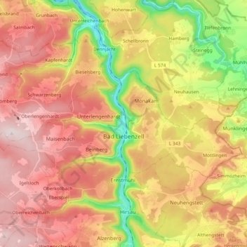
Name: Bad Liebenzell topographic map, elevation, terrain.
Average elevation: 1,752 ft
Minimum elevation: 971 ft
Maximum elevation: 2,382 ft
Make a donation
Gear up for your next adventure:
As an Amazon Associate, this site earns from qualifying purchases at no extra cost to you.
Other topographic maps
Click on a map to view its topography, its elevation and its terrain.
Bad Teinach
Germany > Baden-Württemberg > Landkreis Calw
The township (Stadt) of Bad Teinach-Zavelstein is located at the center of the district of Calw, in Baden-Württemberg, one of the 16 States of the Federal Republic of Germany. Bad Teinach-Zavelstein's municipal area rests upon the plateau of the Enz and Nagold rivers, a landscape defined by severe river…
Average elevation: 1,827 ft
Zieflensberg
Germany > Baden-Württemberg > Landkreis Calw > Bad Herrenalb > Zieflensberg
Average elevation: 2,192 ft
Make a donation
Gear up for your next adventure:
As an Amazon Associate, this site earns from qualifying purchases at no extra cost to you.