
Alta Vista topographic map
Interactive map
Click on the map to display elevation.
About this map
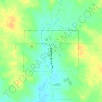
Name: Alta Vista topographic map, elevation, terrain.
Location: Alta Vista, Chickasaw County, Iowa, United States (43.19124 -92.42698 43.20217 -92.40704)
Average elevation: 1,181 ft
Minimum elevation: 1,135 ft
Maximum elevation: 1,237 ft
Other topographic maps
Click on a map to view its topography, its elevation and its terrain.
Fredericksburg
United States > Iowa > Chickasaw County
Fredericksburg, Chickasaw County, Iowa, United States
Average elevation: 1,093 ft
Ionia
United States > Iowa > Chickasaw County
Ionia, Chickasaw County, Iowa, United States
Average elevation: 1,132 ft
Lawler
United States > Iowa > Chickasaw County
Lawler, Chickasaw County, Iowa, United States
Average elevation: 1,109 ft
North Washington
United States > Iowa > Chickasaw County
North Washington, Chickasaw County, Iowa, 50661, United States
Average elevation: 1,129 ft
Nashua
United States > Iowa > Chickasaw County
Nashua, Chickasaw County, Iowa, United States
Average elevation: 991 ft
Bassett
United States > Iowa > Chickasaw County
Bassett, Chickasaw County, Iowa, United States
Average elevation: 1,050 ft
New Hampton
United States > Iowa > Chickasaw County
New Hampton, Chickasaw County, Iowa, 50659, United States
Average elevation: 1,145 ft