Geolocate

Nashua topographic map

Click on the map to display elevation.

About this map

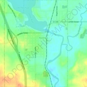
Name: Nashua topographic map, elevation, terrain.

Location: Nashua, Chickasaw County, Iowa, United States (42.93618 -92.55915 42.96545 -92.52527)

Average elevation: 991 ft

Minimum elevation: 945 ft

Maximum elevation: 1,070 ft

Chickasaw County trails, hiking, mountain biking, running and outdoor activities

Gear up for your next adventure:

🔭Compact Binoculars - HD vision for scouting terrain and identifying distant landmarks
🪓Survival Multi‑Tool - Versatile tool for camp and trail tasks
🚪Portable Camp Chair - Foldable chair for comfort at camp
🪶Camp Gear Gift Set - Perfect gift bundle for outdoor fans
🥇GPS Hiking Watch - Multi‑sport GPS watch with navigation and trail tracking

As an Amazon Associate, this site earns from qualifying purchases at no extra cost to you.