
Provincia de Chuy topographic map
Interactive map
Click on the map to display elevation.
About this map
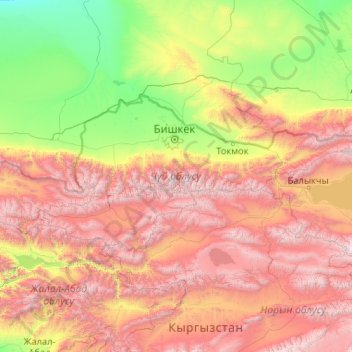
Name: Provincia de Chuy topographic map, elevation, terrain.
Location: Provincia de Chuy, Kirguistán (41.83216 73.05756 43.26680 77.22693)
Average elevation: 5,922 ft
Minimum elevation: 1,257 ft
Maximum elevation: 15,669 ft
Other topographic maps
Click on a map to view its topography, its elevation and its terrain.
СК Связист
Kirguistán > Provincia de Chuy > СК Связист
СК Связист, Сокулукский район, Provincia de Chuy, Kirguistán
Average elevation: 2,087 ft