
Bongard topographic map
Interactive map
Click on the map to display elevation.
About this map
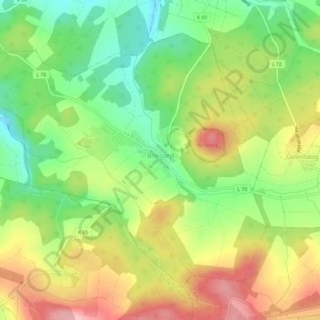
Name: Bongard topographic map, elevation, terrain.
Average elevation: 1,722 ft
Minimum elevation: 1,486 ft
Maximum elevation: 2,001 ft
Other topographic maps
Click on a map to view its topography, its elevation and its terrain.
Stadtkyll
Deutschland > Rheinland-Pfalz > Landkreis Vulkaneifel
Stadtkyll, Gerolstein, Landkreis Vulkaneifel, Rheinland-Pfalz, 54589, Deutschland
Average elevation: 1,775 ft
Hillesheim
Deutschland > Rheinland-Pfalz > Landkreis Vulkaneifel
Hillesheim, Gerolstein, Landkreis Vulkaneifel, Rheinland-Pfalz, 54576, Deutschland
Average elevation: 1,512 ft
Kerpen (Eifel)
Deutschland > Rheinland-Pfalz > Landkreis Vulkaneifel
Kerpen (Eifel), Gerolstein, Landkreis Vulkaneifel, Rheinland-Pfalz, Deutschland
Average elevation: 1,578 ft
Mannebach
Deutschland > Rheinland-Pfalz > Landkreis Vulkaneifel
Mannebach, Kelberg, Landkreis Vulkaneifel, Rheinland-Pfalz, Deutschland
Average elevation: 1,706 ft