
Fucino topographic map
Interactive map
Click on the map to display elevation.
About this map
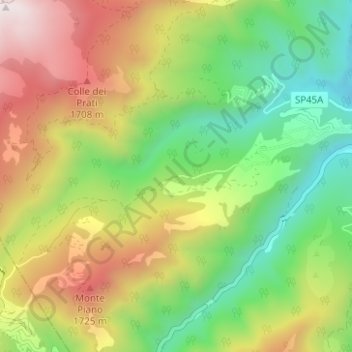
Name: Fucino topographic map, elevation, terrain.
Location: Fucino, Crognaleto, Teramo, ABR, 64043, Italia (42.53591 13.41009 42.56008 13.47248)
Average elevation: 4,121 ft
Minimum elevation: 2,333 ft
Maximum elevation: 6,627 ft
Other topographic maps
Click on a map to view its topography, its elevation and its terrain.
Monte Gorzano
Italia > ABR > Crognaleto
Monte Gorzano, Crognaleto, Teramo, ABR, Italia
Average elevation: 6,880 ft