
Thank you for supporting this site ❤️
Make a donation
Make a donation
Gear up for your next adventure:
As an Amazon Associate, this site earns from qualifying purchases at no extra cost to you.
Stugun topographic map
Click on the map to display elevation.
Thank you for supporting this site ❤️
Make a donation
Make a donation
Gear up for your next adventure:
As an Amazon Associate, this site earns from qualifying purchases at no extra cost to you.
About this map
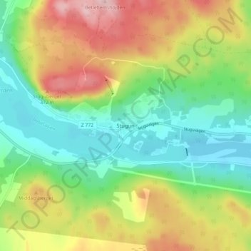
Name: Stugun topographic map, elevation, terrain.
Location: Stugun, Ragunda kommun, Jämtland County, 830 76, Sweden (63.14788 15.58049 63.18788 15.62049)
Average elevation: 925 ft
Minimum elevation: 666 ft
Maximum elevation: 1,319 ft
Thank you for supporting this site ❤️
Make a donation
Make a donation
Gear up for your next adventure:
As an Amazon Associate, this site earns from qualifying purchases at no extra cost to you.