
Río Chinchiná topographic map
Interactive map
Click on the map to display elevation.
About this map
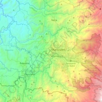
Name: Río Chinchiná topographic map, elevation, terrain.
Location: Río Chinchiná, Villamaría, Centrosur, Caldas, 170008, Colombia (4.98281 -75.67920 5.14053 -75.33028)
Average elevation: 6,450 ft
Minimum elevation: 2,457 ft
Maximum elevation: 15,525 ft
Other topographic maps
Click on a map to view its topography, its elevation and its terrain.
Las Brisas
Colombia > Caldas > Villamaría
Las Brisas, Villamaría, Centrosur, Caldas, RAP del Agua y la Montaña, 176001, Colombia
Average elevation: 6,686 ft
Cabecera Municipal Villamaría
Colombia > Caldas > Villamaría
Cabecera Municipal Villamaría, Villamaría, Centrosur, Caldas, RAP del Agua y la Montaña, 176001, Colombia
Average elevation: 6,398 ft