
Dudh Talai topographic map
Interactive map
Click on the map to display elevation.
About this map
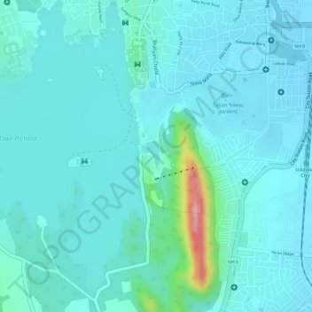
Name: Dudh Talai topographic map, elevation, terrain.
Average elevation: 1,969 ft
Minimum elevation: 1,886 ft
Maximum elevation: 2,428 ft
Other topographic maps
Click on a map to view its topography, its elevation and its terrain.
Lake Pichola
Lake Pichola, ambrai ghat foot path, Udaipur, Girwa Tehsil, Udaipur, Rajasthan, 313001, India
Average elevation: 1,985 ft
moti magri memorial
moti magri memorial, Udaipur, Girwa Tehsil, Udaipur, Rajasthan, 313001, India
Average elevation: 1,955 ft
Jag Mandir Island
Jag Mandir Island, Udaipur, Girwa Tehsil, Udaipur, Rajasthan, 313001, India
Average elevation: 1,991 ft