
Thank you for supporting this site ❤️
Make a donation
Make a donation
Gear up for your next adventure:
As an Amazon Associate, this site earns from qualifying purchases at no extra cost to you.
Rwankuba topographic map
Click on the map to display elevation.
Thank you for supporting this site ❤️
Make a donation
Make a donation
Gear up for your next adventure:
As an Amazon Associate, this site earns from qualifying purchases at no extra cost to you.
About this map
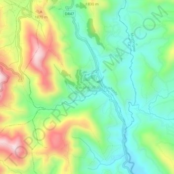
Name: Rwankuba topographic map, elevation, terrain.
Location: Rwankuba, Rushashi, Gakenke, Northern Province, Rwanda (-1.77793 29.84554 -1.73793 29.88554)
Average elevation: 5,666 ft
Minimum elevation: 5,108 ft
Maximum elevation: 6,647 ft
Thank you for supporting this site ❤️
Make a donation
Make a donation
Gear up for your next adventure:
As an Amazon Associate, this site earns from qualifying purchases at no extra cost to you.