
Charlestown Township topographic map
Interactive map
Click on the map to display elevation.
About this map
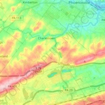
Name: Charlestown Township topographic map, elevation, terrain.
Average elevation: 331 ft
Minimum elevation: 72 ft
Maximum elevation: 715 ft
Other topographic maps
Click on a map to view its topography, its elevation and its terrain.
Charlestown
United States > Pennsylvania > Chester County > Charlestown Township > Charlestown
Charlestown, Charlestown Township, Chester County, Pennsylvania, 19432, United States
Average elevation: 331 ft
Devault
United States > Pennsylvania > Chester County > Charlestown Township
Devault, Charlestown Township, Chester County, Pennsylvania, 19432, United States
Average elevation: 377 ft