
Make a donation
Gear up for your next adventure:
As an Amazon Associate, this site earns from qualifying purchases at no extra cost to you.
Chesterville topographic map
Click on the map to display elevation.
Make a donation
Gear up for your next adventure:
As an Amazon Associate, this site earns from qualifying purchases at no extra cost to you.
About this map
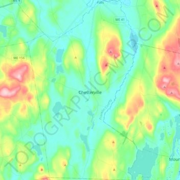
Name: Chesterville topographic map, elevation, terrain.
Location: Chesterville, Franklin County, Maine, United States (44.48524 -70.15248 44.62101 -70.03555)
Average elevation: 512 ft
Minimum elevation: 308 ft
Maximum elevation: 1,070 ft
Franklin County trails, hiking, mountain biking, running and outdoor activities
Make a donation
Gear up for your next adventure:
As an Amazon Associate, this site earns from qualifying purchases at no extra cost to you.
Other topographic maps
Click on a map to view its topography, its elevation and its terrain.
Caribou Mountain
United States > Maine > Franklin County > Skinner Township
Average elevation: 2,835 ft
Caribou Mountain
United States > Maine > Franklin County > Skinner Township
Average elevation: 2,835 ft
Mount Abraham
United States > Maine > Franklin County > Mount Abram Township
Average elevation: 3,012 ft
Make a donation
Gear up for your next adventure:
As an Amazon Associate, this site earns from qualifying purchases at no extra cost to you.