
El Biod topographic map
Interactive map
Click on the map to display elevation.
About this map
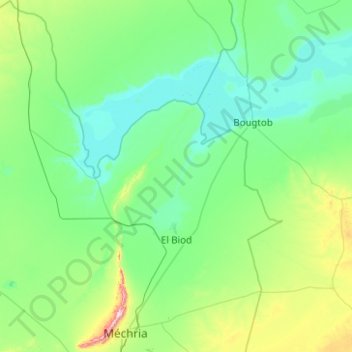
Name: El Biod topographic map, elevation, terrain.
Location: El Biod, daïra Mecheria, Naâma, Algérie (33.49835 -0.77199 34.32588 0.16964)
Average elevation: 3,533 ft
Minimum elevation: 3,205 ft
Maximum elevation: 5,607 ft
Other topographic maps
Click on a map to view its topography, its elevation and its terrain.
Aïn Ben Khellil
Algérie > Naâma > daïra Mecheria > Aïn Ben Khellil
Aïn Ben Khellil, daïra Mecheria, Naâma, Algérie
Average elevation: 4,012 ft
Mécheria
Algérie > Naâma > daïra Mecheria
Mécheria, daïra Mecheria, Naâma, Algérie
Average elevation: 3,743 ft