
Make a donation
Gear up for your next adventure:
As an Amazon Associate, this site earns from qualifying purchases at no extra cost to you.
Campinas topographic map
Click on the map to display elevation.
Make a donation
Gear up for your next adventure:
As an Amazon Associate, this site earns from qualifying purchases at no extra cost to you.
Campinas
This water tower was built between 1936 and 1940 in the highest altitude point inside the urban area, 735 meters above sea level. From its gazebo on the top, one can enjoy a wide panorama view of the city.
Make a donation
Gear up for your next adventure:
As an Amazon Associate, this site earns from qualifying purchases at no extra cost to you.
About this map
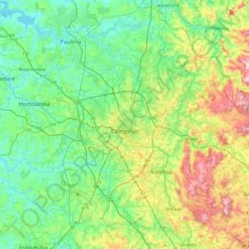
Name: Campinas topographic map, elevation, terrain.
Average elevation: 2,185 ft
Minimum elevation: 1,732 ft
Maximum elevation: 3,337 ft
Make a donation
Gear up for your next adventure:
As an Amazon Associate, this site earns from qualifying purchases at no extra cost to you.
Other topographic maps
Click on a map to view its topography, its elevation and its terrain.
João Aranha
Brazil > São Paulo > Região Metropolitana de Campinas > Paulínia
Average elevation: 1,913 ft