
Rübenzahl topographic map
Interactive map
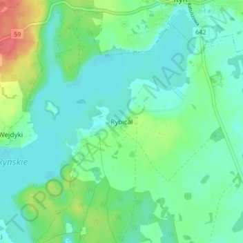
Click on the map to display elevation.
About this map
Name: Rübenzahl topographic map, elevation, terrain.
Average elevation: 417 ft
Minimum elevation: 367 ft
Maximum elevation: 554 ft
Kleinere Orte und Weiler: Bachorza (Wiesenthal) | Dzikowizna | Grzybowo (Grzybowen/Birkensee) | Hermanowa Wola (Hermanawolla/Hermannshorst) | Ławki (osada) (Gut Lawken/Domäne Lauken) | Knis-Podewsie (Gneisthöhe) | Kronowo (osada) | Mleczkowo (Reichenhof) | Mrówki (Mrowken/Neuforst) | Ryn (kolonia) | Ryński Dwór (Rheinshof) | Ryńskie Pole (Rheinsfelde) | Siejkowo (Justusberg) | Skorupki (Skorupken/Schalensee) | Zielony Lasek (Grünwalde)
Other topographic maps
Click on a map to view its topography, its elevation and its terrain.
Sophienthal
Polen > Woiwodschaft Ermland-Masuren > powiat giżycki > Sophienthal
Sophienthal, gmina Ryn, powiat giżycki, Woiwodschaft Ermland-Masuren, 11-520, Polen
Average elevation: 476 ft