
Make a donation
Gear up for your next adventure:
As an Amazon Associate, this site earns from qualifying purchases at no extra cost to you.
Bellante topographic map
Click on the map to display elevation.
Make a donation
Gear up for your next adventure:
As an Amazon Associate, this site earns from qualifying purchases at no extra cost to you.
About this map
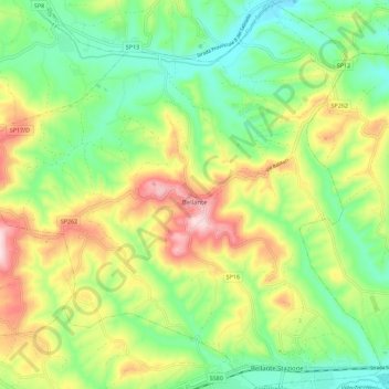
Name: Bellante topographic map, elevation, terrain.
Location: Bellante, Teramo, Abruzzo, Italy (42.70244 13.75139 42.78452 13.86418)
Average elevation: 597 ft
Minimum elevation: 190 ft
Maximum elevation: 1,243 ft
Make a donation
Gear up for your next adventure:
As an Amazon Associate, this site earns from qualifying purchases at no extra cost to you.
Other topographic maps
Click on a map to view its topography, its elevation and its terrain.
La cerqua di Roncacé (quercia secolare)
Italy > Abruzzo > Teramo > Controguerra > San Giovanni II
Average elevation: 646 ft
Make a donation
Gear up for your next adventure:
As an Amazon Associate, this site earns from qualifying purchases at no extra cost to you.
Make a donation
Gear up for your next adventure:
As an Amazon Associate, this site earns from qualifying purchases at no extra cost to you.