
Guanujo topographic map
Interactive map
Click on the map to display elevation.
About this map
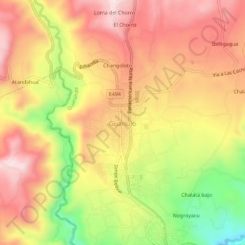
Name: Guanujo topographic map, elevation, terrain.
Location: Guanujo, Guaranda, Bolívar, 020101, Ecuador (-1.58131 -79.02892 -1.54131 -78.98892)
Average elevation: 9,508 ft
Minimum elevation: 8,711 ft
Maximum elevation: 10,062 ft
Other topographic maps
Click on a map to view its topography, its elevation and its terrain.
Antena Claro
Ecuador > Bolívar > Guaranda > Guanujo > Changoloto
Antena Claro, Boyacá, Changoloto, Guanujo, Guaranda, Bolívar, 020101, Ecuador
Average elevation: 9,534 ft