
Hoof topographic map
Interactive map
Click on the map to display elevation.
About this map
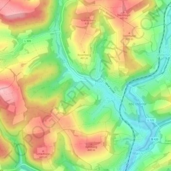
Name: Hoof topographic map, elevation, terrain.
Location: Hoof, Sankt Wendel, Landkreis St. Wendel, Saarland, Deutschland (49.46915 7.20524 49.50526 7.25716)
Average elevation: 1,227 ft
Minimum elevation: 965 ft
Maximum elevation: 1,516 ft
Other topographic maps
Click on a map to view its topography, its elevation and its terrain.
Niederlinxweiler
Deutschland > Saarland > Sankt Wendel
Niederlinxweiler, Sankt Wendel, Landkreis St. Wendel, Saarland, Deutschland
Average elevation: 1,030 ft
Marth
Deutschland > Saarland > Sankt Wendel
Marth, Sankt Wendel, Landkreis St. Wendel, Saarland, Deutschland
Average elevation: 1,234 ft
Saal
Deutschland > Saarland > Sankt Wendel
Saal, Sankt Wendel, Landkreis St. Wendel, Saarland, Deutschland
Average elevation: 1,152 ft
Winterbach
Deutschland > Saarland > Sankt Wendel
Winterbach, Sankt Wendel, Landkreis St. Wendel, Saarland, 66649, Deutschland
Average elevation: 1,106 ft