
Thank you for supporting this site ❤️
Make a donation
Make a donation
Gear up for your next adventure:
As an Amazon Associate, this site earns from qualifying purchases at no extra cost to you.
Freystadt topographic map
Click on the map to display elevation.
Thank you for supporting this site ❤️
Make a donation
Make a donation
Gear up for your next adventure:
As an Amazon Associate, this site earns from qualifying purchases at no extra cost to you.
About this map
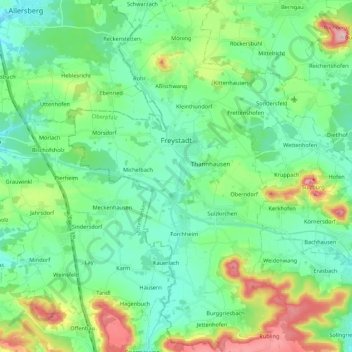
Name: Freystadt topographic map, elevation, terrain.
Average elevation: 1,430 ft
Minimum elevation: 1,250 ft
Maximum elevation: 1,939 ft
Thank you for supporting this site ❤️
Make a donation
Make a donation
Gear up for your next adventure:
As an Amazon Associate, this site earns from qualifying purchases at no extra cost to you.
Other topographic maps
Click on a map to view its topography, its elevation and its terrain.
St. Wolfgang
Germany > Bavaria > Landkreis Neumarkt in der Oberpfalz > Dantersdorf
Average elevation: 1,798 ft
Großbissendorf
Germany > Bavaria > Landkreis Neumarkt in der Oberpfalz > Großbissendorf
Average elevation: 1,614 ft