
Cobb topographic map
Interactive map
Click on the map to display elevation.
About this map
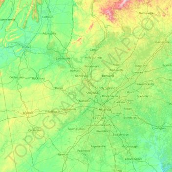
Name: Cobb topographic map, elevation, terrain.
Location: Cobb, Georgia, 30060, United States of America (33.23739 -85.27320 34.63739 -83.87320)
Average elevation: 981 ft
Minimum elevation: 413 ft
Maximum elevation: 3,606 ft
Other topographic maps
Click on a map to view its topography, its elevation and its terrain.
Athens-Clarke County
United States of America > Georgia
Athens-Clarke County, Georgia, United States of America
Average elevation: 712 ft
Berkeley Lake
United States of America > Georgia > Berkeley Lake
Berkeley Lake, Gwinnett County, Georgia, United States of America
Average elevation: 1,020 ft
Gillsville
United States of America > Georgia > Gillsville
Gillsville, Banks County, Georgia, United States of America
Average elevation: 912 ft
Forest Ridge
United States of America > Georgia > Kingsland > Forest Ridge
Forest Ridge, Kingsland, Camden County, Georgia, 31548, United States of America
Average elevation: 26 ft
McRae-Helena
United States of America > Georgia > McRae-Helena
McRae-Helena, Telfair County, Georgia, 31055, United States of America
Average elevation: 210 ft
Hart County
United States of America > Georgia
Hart County, Georgia, United States of America
Average elevation: 738 ft
Dahlonega
United States of America > Georgia > Dahlonega
Dahlonega, Lumpkin County, Georgia, United States of America
Average elevation: 1,348 ft
Birdie
United States of America > Georgia > Birdie
Birdie, Spalding County, Georgia, United States of America
Average elevation: 840 ft
Statesboro
United States of America > Georgia > Statesboro
Statesboro, Bulloch County, Georgia, 30459, United States of America
Average elevation: 217 ft
Brunswick
United States of America > Georgia > Brunswick
Brunswick, Glynn County, Georgia, 31520, United States of America
Average elevation: 7 ft
Leslie
United States of America > Georgia > Leslie
Leslie, Sumter County, Georgia, United States of America
Average elevation: 335 ft
Ringgold
United States of America > Georgia > Ringgold
Ringgold, Catoosa County, Georgia, United States of America
Average elevation: 879 ft
Carey Park
United States of America > Georgia > Atlanta > Carey Park
Carey Park, Atlanta, Fulton County, Georgia, 30369, United States of America
Average elevation: 886 ft
Cuthbert
United States of America > Georgia > Cuthbert > Cuthbert
Cuthbert, Randolph County, Georgia, 39840, United States of America
Average elevation: 453 ft
Chatham City
United States of America > Georgia > Garden City > Chatham City
Chatham City, Garden City, Chatham County, Georgia, 31408, United States of America
Average elevation: 23 ft
Mount Vernon
United States of America > Georgia > Mount Vernon
Mount Vernon, Catoosa County, Georgia, United States of America
Average elevation: 925 ft
Waycross
United States of America > Georgia > Waycross
Waycross, Ware County, Georgia, 31501, United States of America
Average elevation: 135 ft
Lashley
United States of America > Georgia > Lashley
Lashley, Houston County, Georgia, 31005, United States of America
Average elevation: 358 ft
Norman Creek
United States of America > Georgia
Norman Creek, Carroll County, Georgia, 30116, United States of America
Average elevation: 1,158 ft
Newnan
United States of America > Georgia > Newnan
Newnan, Coweta, Georgia, 30263, United States of America
Average elevation: 892 ft
Albany
United States of America > Georgia > Albany
Albany, Dougherty County, Georgia, United States of America
Average elevation: 213 ft
Barrow County
United States of America > Georgia
Barrow County, Georgia, United States of America
Average elevation: 856 ft