Geolocate

Independence topographic map

Click on the map to display elevation.

About this map

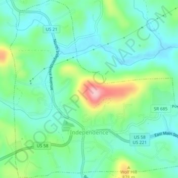
Name: Independence topographic map, elevation, terrain.

Location: Independence, Grayson County, Virginia, 24348, United States (36.61515 -81.16653 36.64319 -81.13248)

Average elevation: 2,680 ft

Minimum elevation: 2,516 ft

Maximum elevation: 3,117 ft

Grayson County trails, hiking, mountain biking, running and outdoor activities

Other topographic maps

Click on a map to view its topography, its elevation and its terrain.

Mouth of Wilson

United States > Virginia > Grayson County

Average elevation: 2,618 ft

Whitetop

United States > Virginia > Grayson County

Average elevation: 3,632 ft

Volney

United States > Virginia > Grayson County

Average elevation: 2,923 ft

Elk Creek

United States > Virginia > Grayson County

Average elevation: 2,654 ft

Whitetop

United States > Virginia > Grayson County

Average elevation: 3,632 ft

Elk Creek

United States > Virginia > Grayson County

Average elevation: 2,654 ft

Carsonville

United States > Virginia > Grayson County

Average elevation: 2,579 ft

Rugby

United States > Virginia > Grayson County

Average elevation: 3,235 ft

Gear up for your next adventure:

🔌Solar Panel Charger - Charge gear sustainably outdoors
🪶Camping Sleeping Pad - Comfortable sleeping pad for backpacking
📚Navigation Handbooks - Master the art of reading topographic maps and using a compass
📶Vehicle Signal Boosters - Improve reception in rural areas while driving to trailheads
🧦Hiking Socks - Comfortable socks to prevent blisters on long hikes

As an Amazon Associate, this site earns from qualifying purchases at no extra cost to you.