Geolocate

Sabang topographic map

Click on the map to display elevation.

About this map

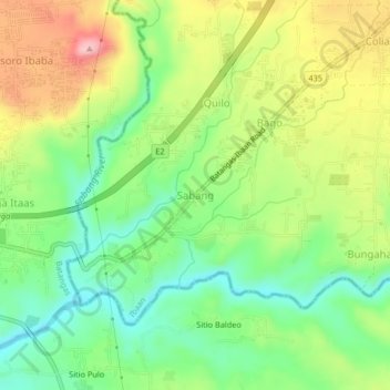
Name: Sabang topographic map, elevation, terrain.

Location: Sabang, Ibaan, Batangas, Calabarzon, 4230, Philippines (13.77940 121.08868 13.81940 121.12868)

Average elevation: 262 ft

Minimum elevation: 30 ft

Maximum elevation: 591 ft

Gear up for your next adventure:

🛠️Outdoor Gear Repair Kit - Essential tools to fix gear on the trail
📖Nature Tracking Books - Learn to track wildlife and terrain
🌡️Portable Weather Meter - Track weather conditions on the trail
Backpacking Tents - Weight-optimized shelters for multi-day topographic surveys
🪶Multi‑Purpose Knife - Useful blade for camp and trail

As an Amazon Associate, this site earns from qualifying purchases at no extra cost to you.