
Make a donation
Gear up for your next adventure:
As an Amazon Associate, this site earns from qualifying purchases at no extra cost to you.
Jijiga topographic map
Click on the map to display elevation.
Make a donation
Gear up for your next adventure:
As an Amazon Associate, this site earns from qualifying purchases at no extra cost to you.
Jijiga
Jijiga (Somali: Jigjiga, Amharic: ጅጅጋ, Jijiga) is the capital city of Somali Region, Ethiopia. It became the capital of the Somali Region in 1995 after it was moved from Gode. Located in the Fafan Zone with 70 km (37 mi) west of the border with Somalia, the city has an elevation of 1,634 metres above sea level. Jigjiga is traditionally the seat of the Bartire Garad Wiil-Waal of the Jidwaaq Absame. The International airport is named after him.
Make a donation
Gear up for your next adventure:
As an Amazon Associate, this site earns from qualifying purchases at no extra cost to you.
About this map
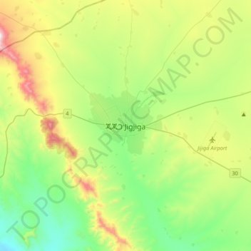
Name: Jijiga topographic map, elevation, terrain.
Location: Jijiga, Fafan, Somali Region, Ethiopia (9.19085 42.64038 9.51085 42.96038)
Average elevation: 5,682 ft
Minimum elevation: 4,570 ft
Maximum elevation: 8,117 ft
Make a donation
Gear up for your next adventure:
As an Amazon Associate, this site earns from qualifying purchases at no extra cost to you.
Other topographic maps
Click on a map to view its topography, its elevation and its terrain.