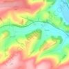
Knighton topographic map
Click on the map to display elevation.
Knighton
The town became a borough in 1203, with a charter permitting a weekly market and annual fair. The presence of two castles within a comparatively small town suggests that one (the earlier motte and bailey sited atop the town) went out of use before the establishment of the second (the motte with no bailey at Bryn y Castell). As Knighton Castle was captured and destroyed by Llewelyn ap Gruffyd in 1262, it seems likely that the second, later castle at Bryn y Castell was undertaken after that and was likely sited on lower ground so as to guard the crossing point of the River Teme. Bryn y Castell, as the one surviving castle in Knighton by then, was besieged by Owain Glyndŵr in 1402 and destroyed along with much of the town. The major battle of the rebellion was fought in the same year at Pilleth (Welsh: Bryn Glas) 3 miles (5 km), south of the town. Though documents pertaining to the defence of Knighton during the Glyndwr rebellion state that Knighton had stout and defensible walls, no historical, archaeological or topographic evidence for a town wall, even of timber, has been found. So it is thought more likely that the statement referred to the castle walls, rather than the town.
About this map
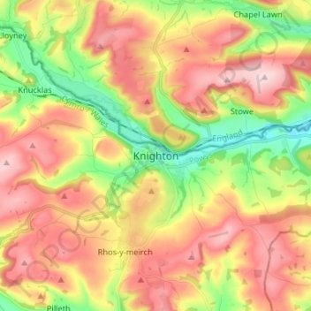
Name: Knighton topographic map, elevation, terrain.
Location: Knighton, Powys, Wales, LD7 1BS, United Kingdom (52.30435 -3.08956 52.38435 -3.00956)
Average elevation: 968 ft
Minimum elevation: 482 ft
Maximum elevation: 1,434 ft
Other topographic maps
Click on a map to view its topography, its elevation and its terrain.
Brecon Beacons National Park
United Kingdom > Wales > Powys
Brecon Beacons National Park, officially named Bannau Brycheiniog National Park (Welsh pronunciation), is a national park in Wales. It is named after the Brecon Beacons (Welsh: Bannau Brycheiniog), the mountain range at its centre. The national park includes the highest mountain in South Wales, Pen y Fan,…
Average elevation: 886 ft