
Make a donation
Gear up for your next adventure:
As an Amazon Associate, this site earns from qualifying purchases at no extra cost to you.
Cerro de Pasco topographic map
Click on the map to display elevation.
Make a donation
Gear up for your next adventure:
As an Amazon Associate, this site earns from qualifying purchases at no extra cost to you.
Cerro de Pasco
Cerro de Pasco is a city in central Peru, located at the top of the Andean Mountains. It is the capital of both the Pasco Province and the Department of Pasco, and an important mining center of silver, copper, zinc and lead. At an elevation of 4,330 metres (14,210 ft), it is one of the highest cities in the world, and with a population of 58,899, it is the highest or the second highest city with over 50,000 inhabitants. The elevation reaches up to 4,380 metres or 14,370 feet in the Yanacancha area. The city has a very intense cold climate and it is connected by road and by rail (via Ferrocarril Central Andino) to the capital Lima, 300 kilometres or 190 miles away. Its urban area is formed by the districts of Chaupimarca, Yanacancha and Simón Bolívar.
Make a donation
Gear up for your next adventure:
As an Amazon Associate, this site earns from qualifying purchases at no extra cost to you.
About this map
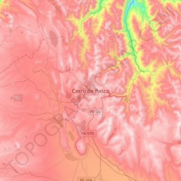
Name: Cerro de Pasco topographic map, elevation, terrain.
Average elevation: 13,907 ft
Minimum elevation: 11,109 ft
Maximum elevation: 15,098 ft
Make a donation
Gear up for your next adventure:
As an Amazon Associate, this site earns from qualifying purchases at no extra cost to you.
Other topographic maps
Click on a map to view its topography, its elevation and its terrain.
Villa Rica
The District of Villa Rica is on the eastern slopes of the Andes mountains in an area of abundant rainfall and mild temperatures. It is located in the ecological zone of the Peruvian Yungas, or Ceja de Selva ("eyebrow of the jungle"), the transition zone between the low jungles of the Amazon Basin and the…
Average elevation: 5,604 ft
Make a donation
Gear up for your next adventure:
As an Amazon Associate, this site earns from qualifying purchases at no extra cost to you.
Province of Oxapampa
Oxapampa is the largest of three provinces that make up the Pasco Region in Peru. The capital of the province is the city of Oxapampa. The province is located on the eastern slopes of the Andes reaching down to the lowlands of the Amazon Basin. The high point of the province is approximately 5,300 metres…
Average elevation: 4,423 ft
Villa Rica
The District of Villa Rica is on the eastern slopes of the Andes mountains in an area of abundant rainfall and mild temperatures. It is located in the ecological zone of the Peruvian Yungas, or Ceja de Selva ("eyebrow of the jungle"), the transition zone between the low jungles of the Amazon Basin and the…
Average elevation: 5,604 ft