Adana topographic map
Click on the map to display elevation.
Adana
Heading west across Cilicia from Adana, the path to Tarsus crosses the foothills of the Taurus Mountains, eventually reaching an altitude of nearly 1,200 metres (4,000 ft) while passing through the Cilician Gates (Turkish: Gülek Boğazı), a rocky mountain pass functioning as the main artery to the Turkish hinterland.
About this map
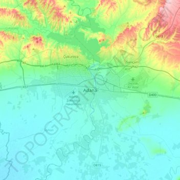
Name: Adana topographic map, elevation, terrain.
Location: Adana, Seyhan, Adana, Mediterranean Region, 01010, Turkey (36.82636 35.16529 37.14636 35.48529)
Average elevation: 200 ft
Minimum elevation: 10 ft
Maximum elevation: 1,024 ft
Other topographic maps
Click on a map to view its topography, its elevation and its terrain.