
Thunderbird Glacier topographic map
Interactive map
Click on the map to display elevation.
About this map
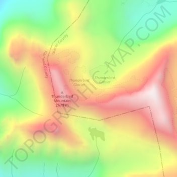
Name: Thunderbird Glacier topographic map, elevation, terrain.
Average elevation: 7,093 ft
Minimum elevation: 5,095 ft
Maximum elevation: 9,085 ft
Other topographic maps
Click on a map to view its topography, its elevation and its terrain.
Hudson Glacier
USA > Montana > Wurtz Hill
Hudson Glacier, Boulder Pass, Wurtz Hill, Flathead County, Montana, USA
Average elevation: 6,821 ft
Herbst Glacier
USA > Montana > Wurtz Hill
Herbst Glacier, Boulder Pass, Wurtz Hill, Flathead County, Montana, USA
Average elevation: 6,624 ft
Harris Glacier
USA > Montana > Wurtz Hill
Harris Glacier, Boulder Pass, Wurtz Hill, Flathead County, Montana, USA
Average elevation: 7,014 ft
Boulder Glacier
USA > Montana > Wurtz Hill
Boulder Glacier, Boulder Pass, Wurtz Hill, Flathead County, Montana, USA
Average elevation: 6,906 ft
Dixon Glacier
USA > Montana > Wurtz Hill
Dixon Glacier, Boulder Pass, Wurtz Hill, Flathead County, Montana, USA
Average elevation: 7,192 ft