
Listringen topographic map
Interactive map
Click on the map to display elevation.
About this map
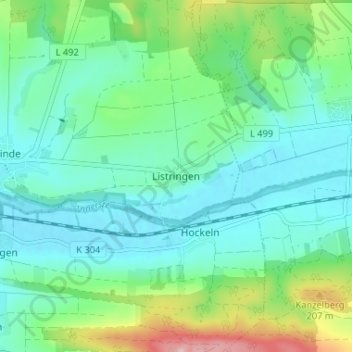
Name: Listringen topographic map, elevation, terrain.
Average elevation: 423 ft
Minimum elevation: 272 ft
Maximum elevation: 906 ft
Other topographic maps
Click on a map to view its topography, its elevation and its terrain.
Detfurth
Deutschland > Niedersachsen > Landkreis Hildesheim > Bad Salzdetfurth
Detfurth, Bad Salzdetfurth, Landkreis Hildesheim, Niedersachsen, 31162, Deutschland
Average elevation: 518 ft
Bodenburg
Deutschland > Niedersachsen > Landkreis Hildesheim > Bad Salzdetfurth
Bodenburg, Bad Salzdetfurth, Landkreis Hildesheim, Niedersachsen, 31162, Deutschland
Average elevation: 499 ft
Lechstedt
Deutschland > Niedersachsen > Landkreis Hildesheim > Bad Salzdetfurth > Lechstedt
Lechstedt, Bad Salzdetfurth, Landkreis Hildesheim, Niedersachsen, 31141, Deutschland
Average elevation: 433 ft
Groß Düngen
Deutschland > Niedersachsen > Landkreis Hildesheim > Bad Salzdetfurth > Groß Düngen
Groß Düngen, Bad Salzdetfurth, Landkreis Hildesheim, Niedersachsen, 31162, Deutschland
Average elevation: 381 ft