
Hoogste punt Vilvoorde topographic map
Interactive map
Click on the map to display elevation.
About this map
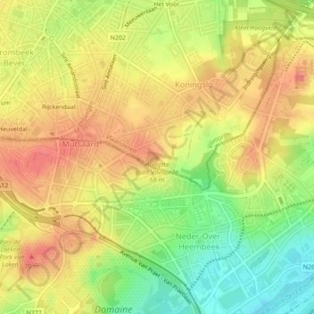
Name: Hoogste punt Vilvoorde topographic map, elevation, terrain.
Average elevation: 161 ft
Minimum elevation: 33 ft
Maximum elevation: 249 ft
Other topographic maps
Click on a map to view its topography, its elevation and its terrain.
Vilvoorde
België > Vlaams-Brabant > Halle-Vilvoorde > Vilvoorde
Vilvoorde, Halle-Vilvoorde, Vlaams-Brabant, Vlaanderen, België
Average elevation: 79 ft
Peutie
België > Vlaams-Brabant > Halle-Vilvoorde > Vilvoorde
Peutie, Vilvoorde, Halle-Vilvoorde, Vlaams-Brabant, Vlaanderen, België
Average elevation: 49 ft
Drie Fonteinen
België > Vlaams-Brabant > Halle-Vilvoorde > Vilvoorde
Drie Fonteinen, Vilvoorde, Halle-Vilvoorde, Vlaams-Brabant, 1800, België
Average elevation: 85 ft