
Vijayapuri South topographic map
Interactive map
Click on the map to display elevation.
About this map
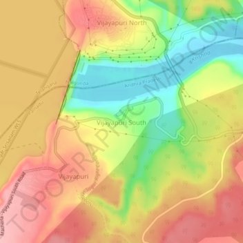
Name: Vijayapuri South topographic map, elevation, terrain.
Average elevation: 469 ft
Minimum elevation: 220 ft
Maximum elevation: 663 ft
Other topographic maps
Click on a map to view its topography, its elevation and its terrain.
Nagarjun Sagar Dam
India > Andhra Pradesh > Macherla > Vijayapuri
Nagarjun Sagar Dam, Vijayapuri, Macherla, Guntur, Andhra Pradesh, 522439, India
Average elevation: 472 ft
Nallamala Forest
India > Andhra Pradesh > Macherla
Nallamala Forest, Macherla, Palnadu, Andhra Pradesh, India
Average elevation: 600 ft