
Laeken - Laken topographic map
Interactive map
Click on the map to display elevation.
About this map
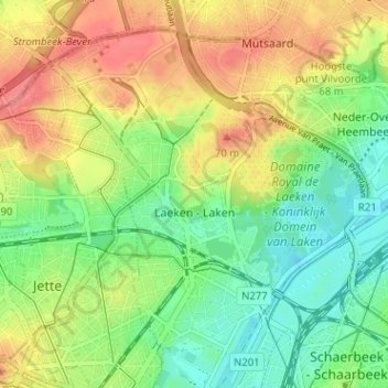
Name: Laeken - Laken topographic map, elevation, terrain.
Location: Laeken - Laken, Brussels, Brussels-Capital, 1020, Belgium (50.86827 4.31400 50.90238 4.37758)
Average elevation: 138 ft
Minimum elevation: 33 ft
Maximum elevation: 262 ft
Other topographic maps
Click on a map to view its topography, its elevation and its terrain.
Parc du Cinquantenaire - Jubelpark
Belgium > Brussels-Capital > Brussels
Parc du Cinquantenaire - Jubelpark, Brussels, Brussels-Capital, 1040, Belgium
Average elevation: 249 ft
Parc de Laeken - Park van Laken
Belgium > Brussels-Capital > Brussels > Laeken - Laken
Parc de Laeken - Park van Laken, Laeken - Laken, Brussels, Brussels-Capital, 1020, Belgium
Average elevation: 154 ft