Refuge d'i Paliri topographic map
Interactive map
Click on the map to display elevation.
About this map
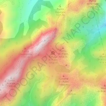
Name: Refuge d'i Paliri topographic map, elevation, terrain.
Average elevation: 2,815 ft
Minimum elevation: 1,444 ft
Maximum elevation: 4,081 ft

Click on the map to display elevation.
Name: Refuge d'i Paliri topographic map, elevation, terrain.
Average elevation: 2,815 ft
Minimum elevation: 1,444 ft
Maximum elevation: 4,081 ft