
Lupken topographic map
Interactive map
Click on the map to display elevation.
About this map
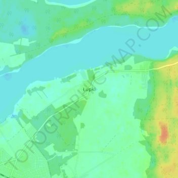
Name: Lupken topographic map, elevation, terrain.
Average elevation: 387 ft
Minimum elevation: 358 ft
Maximum elevation: 459 ft
Other topographic maps
Click on a map to view its topography, its elevation and its terrain.
Falkendorf
Polen > Woiwodschaft Ermland-Masuren > Landkreis Johannisburg
Falkendorf, Gemeinde Gehlenburg, Landkreis Johannisburg, Woiwodschaft Ermland-Masuren, 12-230, Polen
Average elevation: 522 ft
Morgen
Polen > Woiwodschaft Ermland-Masuren > Landkreis Johannisburg
Morgen, Gemeinde Gehlenburg, Landkreis Johannisburg, Woiwodschaft Ermland-Masuren, 12-230, Polen
Average elevation: 512 ft