Geolocate

Allendale topographic map

Click on the map to display elevation.

About this map

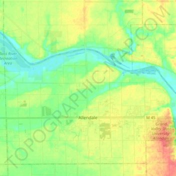
Name: Allendale topographic map, elevation, terrain.

Location: Allendale, Allendale Charter Township, Ottawa County, Michigan, 49401, United States (42.95759 -86.02637 43.02392 -85.87491)

Average elevation: 640 ft

Minimum elevation: 574 ft

Maximum elevation: 728 ft

Ottawa County trails, hiking, mountain biking, running and outdoor activities

Other topographic maps

Click on a map to view its topography, its elevation and its terrain.

Nunica

United States > Michigan > Ottawa County > Crockery Township

Average elevation: 623 ft

Borculo

United States > Michigan > Ottawa County > Olive Township

Average elevation: 646 ft

West Olive

United States > Michigan > Ottawa County

Average elevation: 620 ft

Wright

United States > Michigan > Ottawa County > Wright Township

Average elevation: 869 ft

Aman Park

United States > Michigan > Ottawa County > Tallmadge

Average elevation: 679 ft

Grand Valley

United States > Michigan > Ottawa County

Average elevation: 653 ft

Port Sheldon

United States > Michigan > Ottawa County

Average elevation: 607 ft

Gear up for your next adventure:

🌡️Handheld Weather Meters - Measure wind, temp, and pressure for safe mountain travel
📦Dry Bags Set - Waterproof storage for electronics and clothes
🧭GPS Watch Accessories - Bands and chargers for GPS watches
🦶Hiking Gaiters - Keep debris and water out of your boots
📱Heavy-Duty Phone Cases - Drop-proof and waterproof protection for outdoor navigation

As an Amazon Associate, this site earns from qualifying purchases at no extra cost to you.