Geolocate

Spongano topographic map

Click on the map to display elevation.

About this map

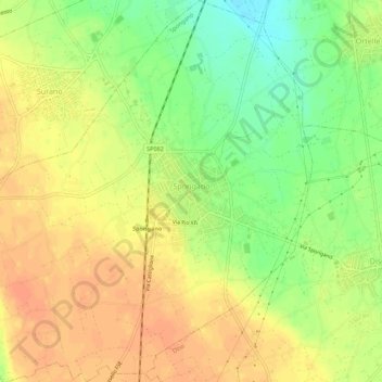
Name: Spongano topographic map, elevation, terrain.

Location: Spongano, Lecce, Apulia, 73038, Italy (39.99610 18.33204 40.03835 18.38313)

Average elevation: 331 ft

Minimum elevation: 253 ft

Maximum elevation: 381 ft

Other topographic maps

Click on a map to view its topography, its elevation and its terrain.

Santa Maria al Bagno

Italy > Apulia > Lecce > Nardò

Average elevation: 105 ft

Torre Chianca

Italy > Apulia > Lecce > Lecce

Average elevation: 7 ft

Madonna di Roca Vecchia

Italy > Apulia > Lecce > Roca

Average elevation: 20 ft

Gear up for your next adventure:

🧷Carabiner Set - Durable clips for gear attachment
🛰️Handheld GPS Units - Professional satellite navigators for precise backcountry mapping
🥩Freeze-Dried Meals - Nutritious and lightweight food for remote expeditions
🎒Trail Energy Bars - High‑calorie bars for hiking energy
🗃️Trail First Aid Kit - Essential kit for outdoor injuries and emergencies

As an Amazon Associate, this site earns from qualifying purchases at no extra cost to you.