
The Solent topographic map
Interactive map
Click on the map to display elevation.
About this map
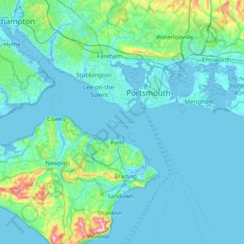
Name: The Solent topographic map, elevation, terrain.
Location: The Solent, Gosport, Hampshire, England, United Kingdom (50.68400 -1.58031 50.83349 -1.03041)
Average elevation: 72 ft
Minimum elevation: -13 ft
Maximum elevation: 787 ft
Other topographic maps
Click on a map to view its topography, its elevation and its terrain.
Clayhall
United Kingdom > England > Hampshire > Gosport
Clayhall, Gosport, Hampshire, England, PO12 1SU, United Kingdom, Haslar Lake
Average elevation: 7 ft