
Brownwood topographic map
Interactive map
Click on the map to display elevation.
About this map
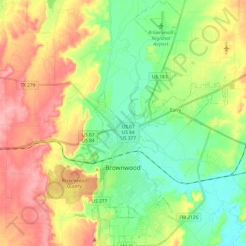
Name: Brownwood topographic map, elevation, terrain.
Location: Brownwood, Brown County, Texas, 76801, United States (31.65910 -99.01309 31.80845 -98.94199)
Average elevation: 1,440 ft
Minimum elevation: 1,296 ft
Maximum elevation: 1,637 ft
Other topographic maps
Click on a map to view its topography, its elevation and its terrain.
Grosvenor
United States > Texas > Brown County
Grosvenor, Brown County, Texas, United States
Average elevation: 1,516 ft
Lake Brownwood
United States > Texas > Brown County
Lake Brownwood, Brown County, Texas, United States
Average elevation: 1,444 ft
May
United States > Texas > Brown County
May, Brown County, Texas, United States
Average elevation: 1,660 ft
Shamrock Shores
United States > Texas > Brown County
Shamrock Shores, Brown County, Texas, United States
Average elevation: 1,490 ft
Early
United States > Texas > Brown County
Early, Brown County, Texas, 76802, United States
Average elevation: 1,385 ft
Bangs
United States > Texas > Brown County
Bangs, Brown County, Texas, 76823, United States
Average elevation: 1,627 ft