Geolocate

Bangs topographic map

Click on the map to display elevation.

About this map

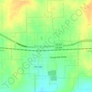
Name: Bangs topographic map, elevation, terrain.

Location: Bangs, Brown County, Texas, 76823, United States (31.70291 -99.14260 31.73122 -99.11698)

Average elevation: 1,627 ft

Minimum elevation: 1,575 ft

Maximum elevation: 1,673 ft

Brown County trails, hiking, mountain biking, running and outdoor activities

Other topographic maps

Click on a map to view its topography, its elevation and its terrain.

May

United States > Texas > Brown County

Average elevation: 1,660 ft

Zephyr

United States > Texas > Brown County > Zephyr

Average elevation: 1,509 ft

Gear up for your next adventure:

🛌Ultralight Sleeping Bags - Compact down bags for cold nights in the wilderness
🌲Outdoor Survival Books - Best books on survival skills
🪵Folding Camp Saw - Compact saw for wood and campsite work
🚑Emergency Bivvies - Heat-reflective sleeping bags for survival situations
🎒Trail Energy Bars - High‑calorie bars for hiking energy

As an Amazon Associate, this site earns from qualifying purchases at no extra cost to you.