
Santa Ana topographic map
Interactive map
Click on the map to display elevation.
About this map
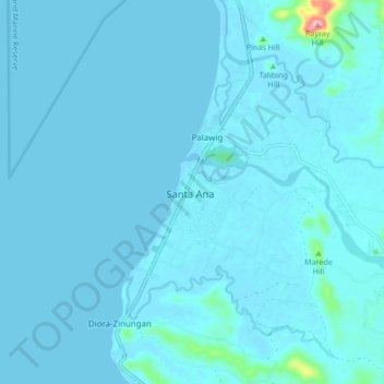
Name: Santa Ana topographic map, elevation, terrain.
Location: Santa Ana, Cagayan, Cagayan Valley, 3514, Philippines (18.41767 122.10252 18.49767 122.18252)
Average elevation: 23 ft
Minimum elevation: -23 ft
Maximum elevation: 538 ft
Other topographic maps
Click on a map to view its topography, its elevation and its terrain.
Pozo Robo
Philippines > Cagayan > Santa Ana
Pozo Robo, Santa Ana, Cagayan, Cagayan Valley, 3514, Philippines
Average elevation: 92 ft