
Municipality of Ilion topographic map
Interactive map
Click on the map to display elevation.
About this map
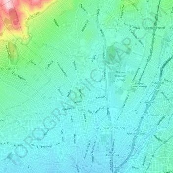
Name: Municipality of Ilion topographic map, elevation, terrain.
Average elevation: 371 ft
Minimum elevation: 187 ft
Maximum elevation: 1,201 ft
Other topographic maps
Click on a map to view its topography, its elevation and its terrain.
Vouliagmeni Municipal Unit
Greece > Attica > Regional Unit of East Attica
Vouliagmeni Municipal Unit, Municipality of Vari - Voula - Vouliagmeni, Regional Unit of East Attica, Attica, 166 71, Greece
Average elevation: 66 ft
Piraeus
Greece > Attica > Regional Unit of Piraeus
Piraeus, Municipality of Piraeus, Regional Unit of Piraeus, Attica, 185 35, Greece
Average elevation: 315 ft
Salamis
Greece > Attica > Regional Unit of Islands > Ampelakia Municipal Unit
Salamis, Ampelakia Municipal Unit, Municipality of Salamina, Regional Unit of Islands, Attica, Greece
Average elevation: 125 ft
Municipality of Marousi
Greece > Attica > Regional Unit of North Athens
Municipality of Marousi, Regional Unit of North Athens, Attica, Greece
Average elevation: 735 ft
Athens
Greece > Attica > Regional Unit of Central Athens
Athens, Municipality of Athens, Regional Unit of Central Athens, Attica, 105 57, Greece
Average elevation: 551 ft