
Make a donation
Gear up for your next adventure:
As an Amazon Associate, this site earns from qualifying purchases at no extra cost to you.
Tabernacle Township topographic map
Click on the map to display elevation.
Make a donation
Gear up for your next adventure:
As an Amazon Associate, this site earns from qualifying purchases at no extra cost to you.
About this map
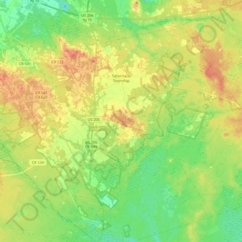
Name: Tabernacle Township topographic map, elevation, terrain.
Average elevation: 85 ft
Minimum elevation: 16 ft
Maximum elevation: 154 ft
Burlington County trails, hiking, mountain biking, running and outdoor activities
Make a donation
Gear up for your next adventure:
As an Amazon Associate, this site earns from qualifying purchases at no extra cost to you.
Other topographic maps
Click on a map to view its topography, its elevation and its terrain.
Kirbys Mill
United States > New Jersey > Burlington County > Medford Township
Average elevation: 49 ft
Hampton Gate
United States > New Jersey > Burlington County > Tabernacle Township
Average elevation: 79 ft
East Riverton
United States > New Jersey > Burlington County > Cinnaminson Township > Riverton
Average elevation: 30 ft
Make a donation
Gear up for your next adventure:
As an Amazon Associate, this site earns from qualifying purchases at no extra cost to you.
Jobstown
United States > New Jersey > Burlington County > Springfield Township
Average elevation: 72 ft
Fostertown
United States > New Jersey > Burlington County > Lumberton Township
Average elevation: 46 ft
Make a donation
Gear up for your next adventure:
As an Amazon Associate, this site earns from qualifying purchases at no extra cost to you.
Timbuctoo
United States > New Jersey > Burlington County > Westampton Township
Average elevation: 46 ft
Marlboro
United States > New Jersey > Burlington County > Evesham Township > Marlton
Average elevation: 85 ft
Make a donation
Gear up for your next adventure:
As an Amazon Associate, this site earns from qualifying purchases at no extra cost to you.
Kirbys Mill
United States > New Jersey > Burlington County > Medford Township
Average elevation: 49 ft
Upper Mill
United States > New Jersey > Burlington County > Pemberton Township
Average elevation: 102 ft
Stow Acres
United States > New Jersey > Burlington County > Evesham Township > Marlton
Average elevation: 79 ft
Make a donation
Gear up for your next adventure:
As an Amazon Associate, this site earns from qualifying purchases at no extra cost to you.
Pine Lane
United States > New Jersey > Burlington County > Springfield Township
Average elevation: 82 ft
Riverton
United States > New Jersey > Burlington County > Cinnaminson Township
Average elevation: 39 ft
Make a donation
Gear up for your next adventure:
As an Amazon Associate, this site earns from qualifying purchases at no extra cost to you.
Fellowship
United States > New Jersey > Burlington County > Mount Laurel Township
Average elevation: 52 ft
Make a donation
Gear up for your next adventure:
As an Amazon Associate, this site earns from qualifying purchases at no extra cost to you.
Make a donation
Gear up for your next adventure:
As an Amazon Associate, this site earns from qualifying purchases at no extra cost to you.