
Thank you for supporting this site ❤️
Make a donation
Make a donation
Gear up for your next adventure:
As an Amazon Associate, this site earns from qualifying purchases at no extra cost to you.
Vajont topographic map
Click on the map to display elevation.
Thank you for supporting this site ❤️
Make a donation
Make a donation
Gear up for your next adventure:
As an Amazon Associate, this site earns from qualifying purchases at no extra cost to you.
About this map
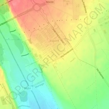
Name: Vajont topographic map, elevation, terrain.
Average elevation: 889 ft
Minimum elevation: 771 ft
Maximum elevation: 1,004 ft
Thank you for supporting this site ❤️
Make a donation
Make a donation
Gear up for your next adventure:
As an Amazon Associate, this site earns from qualifying purchases at no extra cost to you.
Other topographic maps
Click on a map to view its topography, its elevation and its terrain.
Erto / Nert
Italy > Friuli – Venezia Giulia > Pordenone / Pordenon > Erto e Casso
Average elevation: 3,648 ft
Bannia / Banìe
Italy > Friuli – Venezia Giulia > Pordenone / Pordenon > Fiume Veneto
Average elevation: 69 ft