
Liebenwalde topographic map
Interactive map
Click on the map to display elevation.
About this map
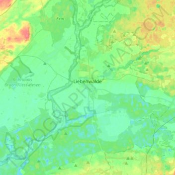
Name: Liebenwalde topographic map, elevation, terrain.
Location: Liebenwalde, Oberhavel, Brandebourg, 16559, Allemagne (52.79551 13.24758 52.93780 13.52308)
Average elevation: 148 ft
Minimum elevation: 105 ft
Maximum elevation: 269 ft
Other topographic maps
Click on a map to view its topography, its elevation and its terrain.
Sonnenberg
Allemagne > Brandebourg > Oberhavel
Sonnenberg, Gransee und Gemeinden, Oberhavel, Brandebourg, Allemagne
Average elevation: 200 ft