
Make a donation
Gear up for your next adventure:
As an Amazon Associate, this site earns from qualifying purchases at no extra cost to you.
Buckfield topographic map
Click on the map to display elevation.
Make a donation
Gear up for your next adventure:
As an Amazon Associate, this site earns from qualifying purchases at no extra cost to you.
About this map
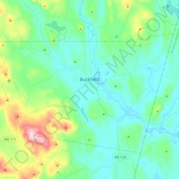
Name: Buckfield topographic map, elevation, terrain.
Location: Buckfield, Oxford County, Maine, 04220, United States (44.23726 -70.45970 44.32774 -70.28151)
Average elevation: 614 ft
Minimum elevation: 295 ft
Maximum elevation: 1,745 ft
Oxford County trails, hiking, mountain biking, running and outdoor activities
Make a donation
Gear up for your next adventure:
As an Amazon Associate, this site earns from qualifying purchases at no extra cost to you.
Other topographic maps
Click on a map to view its topography, its elevation and its terrain.
Sturtevant Pond
United States > Maine > Oxford County > Magalloway Plantation
Average elevation: 1,332 ft
Mad River Falls
United States > Maine > Oxford County > Batchelders Grant Township
Average elevation: 1,624 ft
Make a donation
Gear up for your next adventure:
As an Amazon Associate, this site earns from qualifying purchases at no extra cost to you.