
Lorient topographic map
Interactive map
Click on the map to display elevation.
About this map
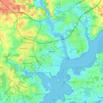
Name: Lorient topographic map, elevation, terrain.
Average elevation: 56 ft
Minimum elevation: -13 ft
Maximum elevation: 190 ft
Lorient (bretonisch: An Oriant) ist eine französische Stadt und Gemeinde mit 57.084 Einwohnern (Stand 1. Januar 2018) im Département Morbihan in der Region Bretagne. Sie liegt am Ufer des Flusses Blavet an der Einmündung des Nebenflusses Scorff in einer Höhenlage von 15 Metern.