
Make a donation
Gear up for your next adventure:
As an Amazon Associate, this site earns from qualifying purchases at no extra cost to you.
Natchitoches topographic map
Click on the map to display elevation.
Make a donation
Gear up for your next adventure:
As an Amazon Associate, this site earns from qualifying purchases at no extra cost to you.
About this map
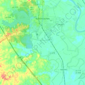
Name: Natchitoches topographic map, elevation, terrain.
Location: Natchitoches, Natchitoches Parish, Louisiana, United States (31.64959 -93.16679 31.79173 -93.05035)
Average elevation: 135 ft
Minimum elevation: 79 ft
Maximum elevation: 308 ft
Natchitoches Parish trails, hiking, mountain biking, running and outdoor activities
Make a donation
Gear up for your next adventure:
As an Amazon Associate, this site earns from qualifying purchases at no extra cost to you.
Other topographic maps
Click on a map to view its topography, its elevation and its terrain.
Make a donation
Gear up for your next adventure:
As an Amazon Associate, this site earns from qualifying purchases at no extra cost to you.
East Natchitoches
United States > Louisiana > Natchitoches Parish > Natchitoches
Average elevation: 125 ft