Geolocate

Ashburton topographic map

Click on the map to display elevation.

About this map

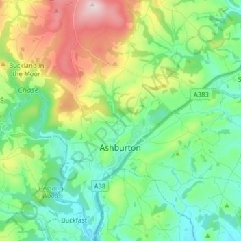
Name: Ashburton topographic map, elevation, terrain.

Location: Ashburton, Teignbridge, Devon, England, United Kingdom (50.48580 -3.79970 50.56766 -3.70627)

Average elevation: 535 ft

Minimum elevation: 98 ft

Maximum elevation: 1,549 ft

Other topographic maps

Click on a map to view its topography, its elevation and its terrain.

Water

United Kingdom > England > Devon > Teignbridge

Average elevation: 856 ft

Higher Ashton

United Kingdom > England > Devon > Teignbridge

Average elevation: 381 ft

Bovey Tracey

United Kingdom > England > Devon > Teignbridge

Average elevation: 358 ft

Gear up for your next adventure:

🥤Water Filter Bottle - All‑in‑one filter bottle for safe hydration
🦺Reflective Outdoor Gear - Safety gear for low‑light conditions
🏥Hiking First Aid Kits - Comprehensive medical kits for remote trail injuries
📱Solar Portable Charger - Solar power bank for charging devices off‑grid
🧥Men's Rain Shells - Premium waterproof and breathable jackets for mountain weather

As an Amazon Associate, this site earns from qualifying purchases at no extra cost to you.